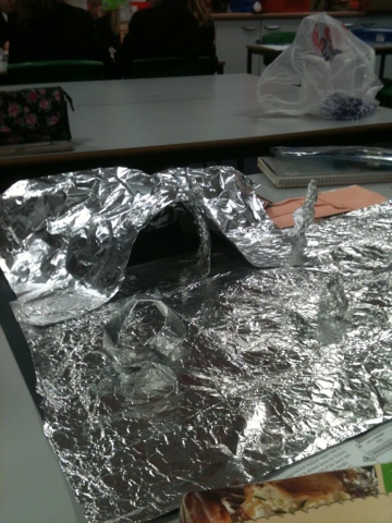
Year 7 have been making some excellent models showing coastal landforms! We have used all our food packaging and other unwanted items! Unfortunately there really is lots of rubbish on our beaches! Time to clean up our act!
Monday 20 May 2013
Thursday 2 May 2013
Geographical Games
Check out these websites for some fun and educational games:
Map Zone:
http://mapzone.ordnancesurvey.co.uk/mapzone/
GIS Zone:
http://mapzone.ordnancesurvey.co.uk/mapzone/giszone/english/
National Disaster Game:
http://www.stopdisastersgame.org/en/home.html
Map Games:
http://www.geography-map-games.com/
National Geographic Games:
http://kids.nationalgeographic.co.uk/kids/games/geographygames/
Sweatshop Game:
http://www.simsweatshop.com/game/
National Disaster Game:
http://www.stopdisastersgame.org/en/home.html
Geography Documentaries of the Week: Check these out as a relaxed way to aid revision:
Megacities: http://www.youtube.com/watch?v=ag-74cPcSjM
The year the earth went wild: http://www.channel4.com/programmes/the-year-the-earth-went-wild/4od
Flooding: http://www.channel4.com/programmes/the-year-britain-flooded/4od
Weather: http://www.channel4.com/programmes/is-our-weather-getting-worse/4od
Weather: http://www.channel4.com/programmes/the-year-britain-froze/4od
Weather: http://www.channel4.com/programmes/the-worlds-weirdest-weather/4od
Hazards (not part of GCSE Syllabus but still a great watch for any keen geographer): http://www.channel4.com/programmes/japans-tsunami-how-it-happened/4od
http://www.channel4.com/programmes/japans-tsunami-caught-on-camera/4od
BBC Coast: http://www.bbc.co.uk/iplayer/episode/b00tfn9l/Coast_Series_5_Gower_to_Anglesey/
Ecosystems:http://www.bbc.co.uk/iplayer/episode/b01qchb0/Natures_Microworlds_Great_Barrier_Reef/
Enjoy :)
Crazy Coasts: Processes & Landforms
Ask yourself the following questions. If you are confident then great. If not, recap from using the information below:
1)
Do you know the four processes of erosion?
2) Do you know the formation of the 3
erosional landforms at the coast?
3) Do you know the four processes of
transportation?
4) Do you understand longshore drift?
5) Do you know the 3 landforms formed by
deposition at the coast?
A
landform is a natural feature of the earth’s surface. Landforms can be created by rivers, glaciers
(large masses of moving ice) and the sea.
•In
coastal regions, landforms are created (and destroyed) by the power of the
sea. A variety of different processes
such as erosion, transportation and deposition all help to create these unique
landforms which are only found in coastal areas.
Waves are the primary force causing erosion along coastlines. A wave is formed by the wind blowing across the surface of the water, creating ripples, which then grow into waves. As waves reach the coast the lower section slows due to friction. The upper section topples over and breaks forward.
The Fetch determines how powerful a wave may be. It is the distance that the wave has travelled. For instance, a wave hitting the coast of Cornwall may have travelled over 4000 miles to get there, all the way across the Atlantic. However a wave hitting Dover may have only travelled the width of the English Channel.
The Strength Of The Wind also influences the power of the waves, so even those with a relatively short fetch can have a great deal of energy, and there fore cause a lot of damage to the coastline.
1. Destructive Waves have a number of important characteristics:
i) Their backwash is much stronger than their swash, thus allowing them to remove material from the beach.
ii) They are frequent in number, usually between 10 and 15 per minute.
iii) They are tall waves, meaning they have a greater distance to fall when they break. This causes them to scour out the beach material.
iv) Destructive waves create a steep narrow beach.
2. Constructive Waves have a number of important characteristics:
i) Their swash is much stronger than their backwash, causing the beach to be built up by the deposited material.
ii) They are less frequent, reaching shore between 6 and 9 times each minute.
iii) They are long waves and so roll onto the beach rather than crashing onto it.
iv) Constructive waves create a wide, gently sloping beach.
The Fetch determines how powerful a wave may be. It is the distance that the wave has travelled. For instance, a wave hitting the coast of Cornwall may have travelled over 4000 miles to get there, all the way across the Atlantic. However a wave hitting Dover may have only travelled the width of the English Channel.
The Strength Of The Wind also influences the power of the waves, so even those with a relatively short fetch can have a great deal of energy, and there fore cause a lot of damage to the coastline.
Destructive waves vs constructive waves
The coastal system is an ever-changing physical environment, powered primarily by the waves. These come in two main forms: destructive (or erosive) waves, and constructive (or depositional) waves.1. Destructive Waves have a number of important characteristics:
i) Their backwash is much stronger than their swash, thus allowing them to remove material from the beach.
ii) They are frequent in number, usually between 10 and 15 per minute.
iii) They are tall waves, meaning they have a greater distance to fall when they break. This causes them to scour out the beach material.
iv) Destructive waves create a steep narrow beach.
2. Constructive Waves have a number of important characteristics:
i) Their swash is much stronger than their backwash, causing the beach to be built up by the deposited material.
ii) They are less frequent, reaching shore between 6 and 9 times each minute.
iii) They are long waves and so roll onto the beach rather than crashing onto it.
iv) Constructive waves create a wide, gently sloping beach.
Processes of coastal erosion:
1. Attrition:- "Rock on rock"
- Particles carried by the waves crash against each other and are broken up into smaller particles.
- "Rock on cliff"
- Particles carried by the waves crash against the cliffs, eroding the cliffs.
- "Rusting / dissolving"
- Salt in the seawater slowly dissolves the cliffs.
- The material produced is carried away by the process of solution.
- "Pressuring"
- The water traps air in cracks and caves in the rock.
- This air is compressed by the incoming waves placing great pressure on the rocks, causing them to crack eventually.
Erosional Landforms
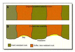
Headlands and Bays.- Formed on an Atlantic (discordant) coastline due to the softer rock being eroded quicker than the harder rock.
- Beaches form in the bays where the soft rock has been eroded away.
- Headlands of more resistant, hard rock are left behind.
Cliffs & Wave Cut Platforms
- Cliffs are formed when destructive waves attack the bottom of the rock face between high and low water mark.
- The area under attack is eroded using the major processes of coastal erosion.
- Points of weakness, such as faults and joints are attacked most, and eventually a wave-cut notch is gouged out.
- The rock above overhangs the notch, and as it is cut deeper into the rock, gravity causes the overhanging rock to collapse.
- The loose rocks are removed by the sea and transported along the coast by long shore drift.
- The whole process of undercutting the cliff begins again.
- As the cliff is eroded backwards it leaves behind a wave-cut platform, at the level of the low water mark.
- This platform is rarely eroded, as the waves energy is concentrated on eroding the area between.
-
Caves, Arches, Stacks and Stumps
- Mainly seen on headlands.
- Waves start by attacking the main points of weakness in the rock: the joints and faults.
- A point of weakness is increased in size until it becomes a cave
- The waves continue to attack the cave, which finally results in an arch being formed through the headland.
- The arch is attacked both by coastal erosion and sub-aerial erosion and finally the roof of the arch falls into the sea.
- This leaves behind a stack, which is then slowly eroded down to become a stump.the high and low water mark, and not the rock that is underneath them.
Transportation
Long shore Drift- Material is moved along the coastline by the waves.
- Waves will often approach the coast at an angle, carrying material with them. This is carried up on to the beach by the swash.
- The material is then dragged out to sea by the backwash, but this time it travels at right angles to the beach, as it will roll down the steepest gradient.
- This movement will slowly transport material laterally along the coast.
Sediment movement:
Long shore drift is the overall process of transportation, however the material actually moves through the four transportation processes seen in rivers. These depend on the size of sediment:
i) Traction - the rolling of large material along the sea floor by the waves.
ii) Saltation - the bouncing of slightly lighter material along the sea floor.
iii) Suspension - Small particles of material carried by the water.
iv) Solution - Material is dissolved and carried by the water.
Coastal Deposition:
- The process associated with constructive waves.
- Material is dropped by waves once they lose energy, either by rolling up a beach or where a river estuary causes a disruption to the normal movement of material along the coast.
- Creates features such as beaches, spits, bars and tombolos.
Spits
are also created by deposition. A spit is an extended stretch of beach
material that projects out to sea and is joined to the mainland at one end.
Spits
are formed where the prevailing wind blows at an angle to the coastline,
resulting in longshore drift. An example of a spit is Spurn Head, found along the Holderness coast in
Humberside.
Year 10
Thursday After School Revision Timetable
Time:
3.25-4.25pm
We will
spend half an hour reviewing the topic and half an hour practising a mock exam.
|
Week commencing
|
Tier and topic
|
|
6th May
|
Foundation: Ecosystems
|
|
13th May
|
Higher: Ecosystems
|
|
20th May
|
Foundation: Desertification
|
|
3rd June
|
Higher: Desertification
|
|
10th June
|
Foundation: Rivers
|
|
17th June
|
Higher: Rivers
|
|
24th June
|
Foundation: Coasts
|
|
1st July
|
NOT ON!
|
|
8TH July
|
Higher: Coasts
|
Geography Club
Every Wednesday lunchtime in K1 we have Geography club. Year 7 students have been busy erupting volcanoes, building shanty towns and writing to their penpals in Uganda and Germany.
Welcome
Welcome to the CHA geog blog. Revision page for GCSE geographers and updates on all the other stuff the department has planned.
Subscribe to:
Posts (Atom)


